Land Life Environment
Broad-scale visualization of the changing land life environment and Its application for the future of the anthroposphere
PI: Yoshihiro Iijima
(Tokyo Metropolitan University)
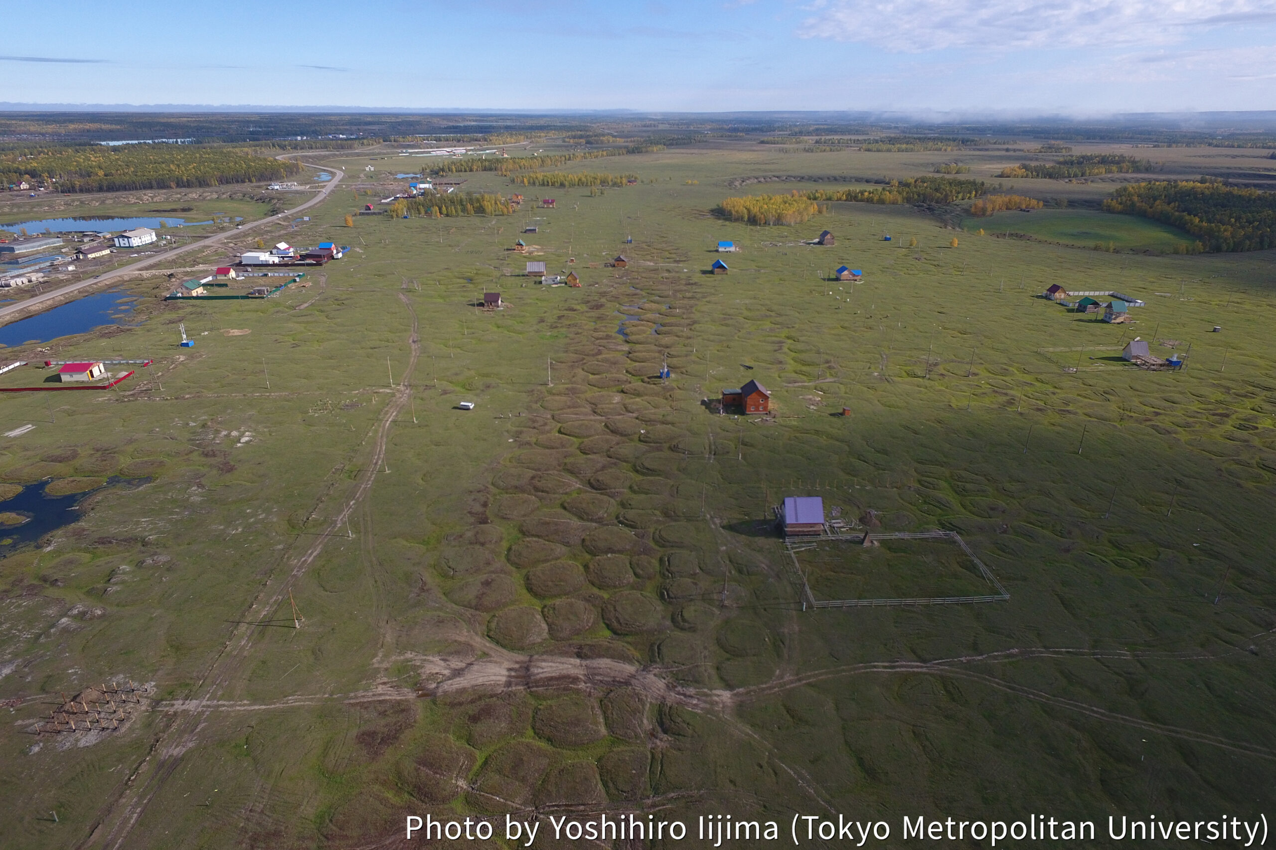
In the Arctic terrestrial region, the shrinking cryosphere and rapid permafrost thaw are increasingly impacting topography, ecosystems, and water environments, with these effects becoming more pronounced in recent decades. For human societies reliant on terrestrial resources to achieve their resilience, accurately understanding these changes and implementing necessary countermeasures is crucial. This necessitates providing broad, easily comprehensible information encompassing both natural environmental and socio-humanistic aspects. This research project aims to comprehensively understand the impact of Arctic environmental changes on human societies and provide information beneficial for societal actions. We adopt an inter-disciplinary and transdisciplinary approach, integrating scientific knowledge to offer easily understandable visualized information to society and promote its practical use.
This project comprises four sub-themes.
- “Permafrost and Infrastructure” assesses the impact of permafrost changes on social infrastructure, contributing to sustainable community building in the Arctic.
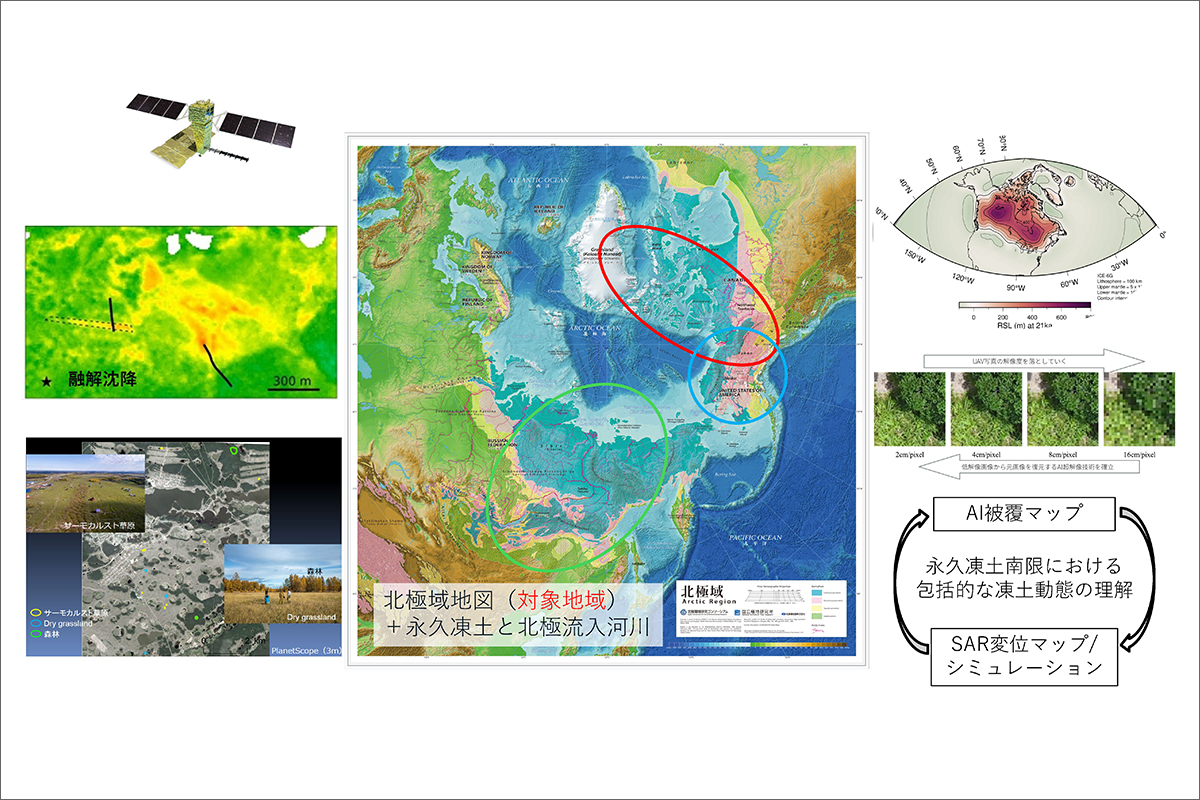
- “Environmental Change Detection” utilizes remote sensing data and advanced data science techniques to visualize permafrost thaw, surface changes, and widespread environmental alterations caused by human activities.
- “Sea Level Projection” provides regional future sea level projections for Greenland and the Alaskan North Slope through field surveys and numerical simulations, aiding in the formulation of coastal social policies.
- “Geographic Information Visualization” organizes the relationship between the Arctic’s natural environment and human activities as geographic information, working with local residents to promote behavioral changes for environmental adaptation through the use of this data.
This project enhances research integration and societal contribution through active collaboration with other research projects in ArCS III and the utilization of research platforms. We integrate evaluations of disaster impacts on human environments and the elucidation of disaster causes with the Climate Disaster Project to deepen our understanding of human-environment interactions. With the Indigenous Peoples Project, we share and integrate the visualization of basin-scale environmental changes and social data analysis, collaborating with local stakeholders to better understand environmental impacts and responses. We will also collaborate with other projects to achieve an integrated understanding of natural and social phenomena. For research platforms, we utilize IARC (International Arctic Research Center, University of Alaska Fairbanks) for field surveys and collaborative research in Alaska, and PFRR (Poker Flat Research Range)satellite and ground observation data for validating InSAR (Interferometric Synthetic Aperture Radar) analysis. JAXA (Japan Aerospace Exploration Agency) satellite data aids in detecting phenomena like land subsidence due to permafrost thaw. The Arctic Regional Simulation System is used for analyzing past and future climate change data. Furthermore, with the Arctic Data Archive System, we are developing integrated geographic information from remote sensing and social statistics, considering public access to facilitate information dissemination to local communities.
Sub-Theme Coordinator (Sub PI)
-
 Kazuyuki Saito (JAMSTEC)
 -
 Takeshi Ise
(Kyoto University) -
 Yusuke Suganuma (NIPR)
 -
 Yoshihiro Iijima (Tokyo Metropolitan University)
-
Reports
- Launched the "Land-Life and Climate" website (In Japanese) ▶ https://land-life-climate.jp/
- Lake bottom sediment coring around Qeqertat
- Ground ice-related landforms (pingo, thermokarst) and spring states, and cold storages in Mongolia
- Field activity in the Poker Flat Research Range, Alaska
- Field survey of saltmarsh on southern Qeqertat
- Arrival at Qeqertat Village!
-
Past Events
Cooperative Institutions
International Arctic Research Center at the University of Alaska Fairbanks (IARC)/ Institute of Geography and Geoecology, Mongolian Academy of Science/ Melnikov Permafrost Institute, Siberian Branch of Russian Academy of Science
Members
| Sub-Theme 1 | |
|---|---|
| Name | Research Institute |
| Kazuyuki Saito | JAMSTEC |
| Shunji Kanie | Hokkaido Univ. of Science |
| Mamoru Ishikawa | Hokkaido Univ. |
| Takahiro Abe | Nagoya Univ. |
| Go Iwahana | Hokkaido Univ. |
| Masato Furuya | Hokkaido Univ. |
| Kazuki Yanagiya | JAXA |
| Jambaljav Yamkhin | GeoCryo, LLC |
| Dashtseren Avirmed | Mongolian Academy of Science |
| Saruulzaya Adjya | Mongolian Academy of Science |
| Sub-Theme 2 | |
|---|---|
| Name | Research Institute |
| Takeshi Ise | Kyoto Univ. |
| Kazuhito Ichii | Chiba Univ. |
| Noriko Kurata | Yamaguchi Prefectural Univ. |
| Kosuke Takaya | Shimane Univ. |
| Takahiro Abe | Nagoya Univ. |
| Sub-Theme 3 | |
|---|---|
| Name | Research Institute |
| Yusuke Suganuma | NIPR |
| Kota Katsuki | Shimane Univ. |
| Takuto Ando | Akita Univ. |
| Jun’ichi Okuno | NIPR |
| Takeshige Ishiwa | NIPR |
| Shuntaro Hata | NIPR |
| Sofia Ribeiro | Geological Survey of Denmark and Greenland (GEUS) |
| Sub-Theme 4 | |
|---|---|
| Name | Research Institute |
| Yoshihiro Iijima | Tokyo Metropolitan Univ. |
| Hitoshi Saito | Nagoya Univ. |
| Nobusuke Iwasaki | Tottori Univ. |
| Takashi Kirimura | Kyoto Sangyo Univ. |
| Masahiro Tanaka | Tokyo Metropolitan Univ. |
| Yuichiro Fujioka | Kyushu Univ. |
| Alexander N. Fedorov | Melnikov Permafrost Institute, SBRAS |
| Sardana Boyakova | Institute of the Humanities and the Indigenous Peoples of the North, SBRAS |
| Timo Kumpla | University of Eastern Finland |